UM Bio Station Fights Shoreline Erosion with New Gravel Beach
By Kelsea Harris-Capuano, University of Montana Environmental Journalism Graduate Student and 2020 FLBS Ted Smith Environmental Storytelling Intern
Physical lake ecologist Dr. Mark Lorang stood on the shorefront of the Flathead Lake Biological Station (FLBS) enthusiastically taking pictures of the beach. “I wish I could have been down here filming it when it was happening,” he said.
Lorang was referring to a brief, intense storm that had rolled through the previous night. Its waves had rearranged the Bio Station’s newly completed erosion control beach, and Lorang wanted to see how it had fared. Lorang meticulously designed this beach to protect a portion of the Bio Station’s shoreline, and its completion meant part of a decades-long plan had finally come to fruition.
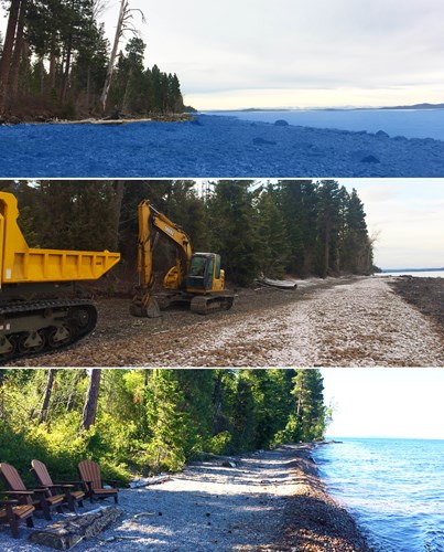
The beach was constructed in March, 2020 when things at FLBS were quiet. For the people working at the Bio Station during beach construction, the sound of heavy machinery and delivery of truckload after truckload of gravel was a change of pace.
Abigail Schmeichel who started working as a K-12 educator at the Bio Station in January said it was an interesting process to watch. Over the course of almost two weeks truckloads of cobble and gravel were continuously transported from Polson and Woods Bay.
“Every day from 8-5pm you could hear the trucks going, beeping, backing up and turning around. It definitely spiced up the week,” Schmeichel said.
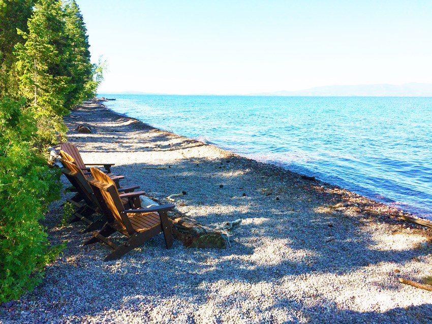
Schmeichel had a front row view of the beach construction from her FLBS apartment and went to check out the process frequently. She said the addition of the beach is nice from a user standpoint. The slope of the bank into the water is less steep and the gravel is easier to walk on.
But the beach wasn’t installed for aesthetics and recreational use, although they are a happy byproduct. It has a very functional purpose. It’s called a “dynamic equilibrium beach,” a beach designed to prevent shoreline erosion and help restore habitat.
Lorang, who is former FLBS faculty, has studied Flathead Lake for over 30 years. His research led him to design soft structure beaches made of varying particle sizes (i.e., gravel and cobble) that can absorb and dissipate incoming wave energy, thus preventing damaging erosion.
The Bio Station beach is made up of varying sizes of rocks that were placed strategically at low water. First a mix of larger cobbles and gravel was placed lower down on the exposed shoreline. That was followed by a smaller cobble mix above the previous layer. And finally, on top of all that a large amount of pea-sized gravel was deposited extending up towards the trees. When the lake’s water levels were brought up in June, only the easy to walk on smaller gravel was left exposed.
When waves break on the gravel it is pushed around as it absorbs the energy. A big storm at a high water level will create a berm or beach crest that is built up by the largest waves tossing larger rocks on top of the smaller gravels. The waves dynamically reshape the gravels into a beach that can break the waves and dissipate the erosive energy. It will take subsequent larger storms to rearrange the beach again.

These images show the progression from the original shoreline (top image, with original waterline shaded in blue), through snowy construction in the spring (middle image), to the newly restored gravel beach shoreline (bottom image).
Ultimately, Lorang has installed a soft structure that mimics what natural beaches do.
Flathead Lake water levels are controlled by the Seli’š Ksanka Qlispe’ Dam, formerly known as Kerr Dam, near Polson. Lake levels fluctuate as much as 10 feet throughout the year. In the summer the water is purposefully kept at a high level or “full pool” for recreational purposes.
In a recent report, Dr. Jack Stanford, former FLBS Director described how in natural conditions the shores of lakes are protected because they experience wave impact at varying water levels that occur during seasonal fluctuations. Stanford continued that erosion at the top of a lake’s shoreline would naturally only occur during the largest floods, and for just a brief period of time.
Artificially keeping the lake at a high level longer accelerates the erosion process during large wind and subsequent wave events.
The Bio Station has lost 1.6 acres of shoreline property since the regulation of Flathead Lake’s water level began in 1938. Diane Whited, FLBS researcher and GIS and remote sensing savant has helped document the Bio Station’s shoreline loss.
Whited, who has worked at FLBS for about 20 years, used to measure shoreline erosion with surveying equipment and erosion pins but now uses drones to take images of the lake shoreline instead.
Whited said that remote sensing is a fast way to collect larger-scale amounts of visual data. She said imagery is useful in that it can quickly and easily communicate what numbers and equations can’t.
“’We’ve lost 20 meters of land over X amount of years.’ Well, you can say that. But if you can visually show that, it's much more powerful,” she said.
The drones also capture imagery of Lorang’s beach projects. Imagery before and after construction, following big storms or 5-10 years down the line helps determine and document the effectiveness of the design-with-nature approach.
Lorang has designed and helped install about 2.5 miles of dynamic equilibrium beaches on Flathead Lake’s shoreline since 1989.
Traditional and most commonly used methods for preventing erosion are hard structures such as seawalls, large barriers usually made of concrete, and riprap, a field of large boulders or objects. Historically large car bodies have been used along river banks called “Detroit riprap.”
These methods have some drawbacks. The energy of a wave is what causes erosion. That energy doesn’t dissipate when it hits a hard structure like a concrete wall Lorang said, but is reflected back into the lake where it interacts with other incoming waves.
This interaction causes scour to the lake bed in front of the seawall and to the adjacent shoreline. That process increases the severity of erosion to the neighboring property. This usually leads to the construction of more seawall and riprap resulting in a domino effect of building seawalls and losing natural beaches.

The drone image, taken in April 2020, shows the restored gravel shoreline during springtime lake levels. The new gravel swim beach at the Flathead Lake Biological Station offers a scenic setting for summer recreation while natural protecting the shoreline from erosion.
Seawalls in particular cause more scour to lake bed resulting in unnatural and harsh environments that plant life can’t grow in. This negatively impacts the aquatic food web as well as the connected terrestrial habitat.
From an aesthetic and recreational standpoint, seawalls and large boulder fields are not as appealing to beach goers and make the shoreline less accessible.
“No one wants to spread their towel on riprap,” Lorang said.
But a challenge for those looking to have an erosion control beach is the expertise needed to design and build them. Installing one of Lorang’s beaches is a much more intricate process than simply dumping a pile of gravel.
Lorang has years of knowledge and experience. He carefully calculates in all the variables. Every shoreline is different and Lorang looks at the characteristics of each individual section of shoreline and the waves affecting it. It isn’t a one size fits all method.
Lorang said beaches moving and being reshaped is a part of the process. It’s normal to see these beaches change after storms. That’s the point of a dynamic structure, it can adapt and change to the variable wave and storm conditions, while dissipating the wave energy that causes shoreline erosion.
These beaches have been slow to grow in popularity and Lorang thinks that people have this perception that a changing or “dynamic” beach means something bad.
But essentially, Lorang is simply providing the right volumes and distributions of gravel material so that the waves can do the work of mimicking what natural beaches do. And natural beaches change over time. Lorang said this method of designing with nature just doesn’t have enough credibility, yet.
“The first thing people do when they buy property out here is stake out their boundaries. Usually that means cutting down trees and building a seawall,” Lorang said.
In total, about 460 feet of FLBS shoreline was transformed with close to 1020 cubic yards of cobble and gravel. In weight that’s about 1,020 Toyota Corollas, or 510 medium sized hippos.
The beach was built with money the Bio Station was awarded in a recent class-action lawsuit for shoreline damages caused by dam-regulated lake levels according to Tom Bansak, FLBS Associate Director.
Bansak said the Bio Station wants their beach to serve as a model of how Lorang’s beach design works over time.
The Bio Station and Lorang have future plans to protect more of its shoreline with this kind of erosion control, Bansak said. This includes the adjacent Yellow Bay Unit of Flathead Lake State Park which sits on FLBS property. Flathead Lake State Park – Yellow Bay is open to the public and sees a lot of summer users on its shrinking shoreline. The Bio Station wants to enhance the visitor experience by helping to restore and protect it.
“From a recreational standpoint, you can't use half the State Park, right? Because you have to fight through the brush to get to the water.” Bansak said.
Flathead Lake State Park manager Amy Grout has been in talks with the Bio Station about an erosion control beach. Yellow Bay is one of six units around the lake that make up Flathead Lake State Park. Grout said the idea of Yellow Bay having one of Lorang’s beaches is exciting.
Grout said that the park’s usable space is shrinking. She has been park manager for five years and within the last year she has noticed notable erosion at Yellow Bay.
“A beach would allow for more usable area of the shoreline for the public,” she said.
The challenge for Yellow Bay is finding the funding. While Grout is on board with putting in a beach, the money just isn’t there. The parks have many facilities that need repairs and upgrades and those take priority she said.Finding funding will be a challenge, but the Bio Station and partners are looking to philanthropy to help foot the bill.
Lorang standing on the new Bio Station beach commented on how the beach has already changed shape, hypothesizing why a curve was created here or debris was deposited there. He wants Whited to fly a drone over to take aerial photos of the beach to document the changes made before and after the storm.
“I’ve been doing this for 40 years and I still get excited about beaches,” Lorang said.


