27.3 miles
Maximum length of Flathead Lake
How big is Flathead Lake? How deep is it? What fish live here, and does the lake ever freeze? Explore facts about Flathead Lake's size, water, wildlife, history and science on this page:
Quick Facts | Size & Depth | Water & Weather | Fish | Geology | Water Quality | History | Map | Lake Levels
One of the West's Largest Natural Lakes
Flathead Lake is the largest natural freshwater lake by surface area in the western United States outside Alaska.
Lake Tahoe contains more water because it is much deeper, while the Great Salt Lake is larger in surface area but contains salt water rather than fresh water.
Flathead Lake is about 27 miles long and more than 15 miles across at its widest point. It covers 191.5 square miles and contains about 5.56 cubic miles of water.
The deepest part of Flathead Lake is 370.7 feet (113 meters) deep. Its average depth is about 164.7 feet (50.2 meters).
Flathead Lake has about 161.4 miles of mainland shoreline and another 26.2 miles around its islands, for a total of about 187.6 miles.
Average surface temperatures change dramatically through the year. They range from about 36°F (2.3°C) in mid-January to 56°F (13.5°C) in mid-June and about 68°F (20.3°C) in mid-August.
Usually, no. Flathead Lake contains an enormous amount of water, and wind can keep its surface moving. It takes an unusually long period of very cold and calm weather for the entire lake to freeze.
Bays and areas near the shoreline may freeze during winter. Historical FLBS observations show that the entire lake once froze about once each decade, but it has not completely frozen since the winters of 1988-89 and 1989-90.
The Flathead River usually reaches its greatest flow during spring snowmelt, generally between May 15 and June 15. The river can carry enough sediment into Flathead Lake to create a visible plume that sometimes extends across the lake.
Flathead Lake's water level changes with the seasons. The lake and its outflow are regulated by Seli’š Ksanka Qlispe’ Dam on the Lower Flathead River near Polson.
Regulation of the dam causes the lake level to fluctuate by approximately 10 feet during the year, generally between elevations of 2,883 and 2,893 feet above sea level.
When mountain snowpack and flood conditions allow, the lake is typically raised during late spring and reaches full pool for summer recreation.


The fish community in Flathead Lake looks very different today than it did more than a century ago.
Beginning in the late 1800s, fisheries managers introduced numerous nonnative fish species to increase fishing opportunities. The later arrival of nonnative Mysis, or opossum shrimp, in the mid-1980s caused additional major changes to the lake's food web.
Today, nonnative species such as lake trout, lake whitefish and yellow perch are prominent members of the lake's fish community.
Introducing a new species can affect many other organisms. Changes to Flathead Lake's fish and food web show how connected the different parts of an ecosystem are.
Native | ||
|---|---|---|
Species, Common Name | Habitats1 | Current Status2,3 |
Bull trout, Salvelinus confluentus | All | C,D, L |
Westslope cutthroat trout, Oncorhynchus clarkii lewisi | All | C,D |
Mountain whitefish, Prosopium williamsoni | All | C,? |
Pygmy whitefish, Prosopium coulterii | FL,L,A | R,? |
Largescale sucker, Catostomus macrocheilus | FL,L,R | C,S |
Longnose sucker, Catostomus catostomus | FL,L,R | C,S |
Northern pikeminnow, Ptychocheilus oregonensis | FL,L,R | C,S |
Peamouth chub, Mylocheilus caurinus | FL,L,R | C,S |
Redside shiner, Richardsonius balteatus | FL,L,R | C,S |
Slimy sculpin, Cottus cognatus | FL,L,R | C,S |
Longnose dace, Rhinichthys cataractae | FLR | C,S |
|
|
|
Nonnative (year introduced) | ||
|---|---|---|
Species, Common Name | Habitats1 | Current Status2,3 |
Lake whitefish (1890), Coregonus clupeaformis | All | A,E |
Lake trout (1905), Salvelinus namaycush | All | A,E |
Rainbow trout (1914), Oncorhynchus mykiss | FL,L,R | A,E |
Brook trout (1913), Salvelinus fontinalis | FL,L,R | A,E |
Yellowstone cutthroat trout (1910s), Oncorhynchus clarkii bouvieri | L,R,A | R4,S |
Golden trout (1960s), Oncorhynchus mykiss aquabonita | L | R4,S |
Brown trout (1910s), Salmo trutta | R,FLR | R,? |
Kokanee salmon (1916), Oncorhynchus nerka | A | R,D |
Arctic grayling (1960s), Thymallus arcticus | L,R,A | R4,S |
Yellow perch (1910), Perca flavescens | FL,L | A,S |
Northern pike (1960s), Esox lucius | FL,L,R | C,E |
Largemouth bass (1898), Micropterus salmoides | FL,L | R,E |
Smallmouth bass (1960s), Micropterus dolomieu | FL,L,FLR | C,E |
Pumpkinseed sunfish (1910), Lepomis gibbosus | FL,L | C,S |
Black bullhead (1910), Ameiurus melas | FL,L | C,S |
Central mudminnow (1990s), Umbra limi | L | R,? |
Brook stickleback (??), Culaea inconstans | FL,L,R | R,? |
Walleye (??), Sander vitreus | L | R4,? |
White sucker (??), Catostomus commersonii | L | R4,? |
Black crappie (??), Pomoxis nigromaculatus | L | R4,? |
Habitats: FL, L, R, A, FLR
Distribution: A, C, R
Trend: S, D, E, ?
Listed: L
Compiled by FLBS and adapted from: B.K. Ellis, J.A. Stanford et al. 2011; Stanford, J.A. and B.K. Ellis 2002; Holton and Johnson 1996; Montana Fisheries Information System; unpublished records; and professional opinion.
A Lake With an Ice Age Story
Flathead Lake is a remnant of ancient Glacial Lake Missoula, which covered much of western Montana until roughly 15,000 years ago.
During the Ice Age, an enormous glacier blocked the Clark Fork River and created a huge lake behind a natural ice dam. When that ice dam failed, tremendous amounts of water rushed west across what is now Idaho, Washington and Oregon.
These repeated floods moved enormous amounts of rock and sediment and helped create famous landscapes including the scablands of eastern Washington and the Columbia River Gorge.
Flathead Lake's Ice Age story is connected to landscapes hundreds of miles away in the Pacific Northwest.
Flathead Lake is known for its clear water, but keeping the lake healthy requires careful monitoring and protection.
Long-term monitoring by scientists at the Flathead Lake Biological Station detected signs of declining water quality, including increased algal growth and decreases in oxygen in deep water. Nutrients from human sources and shoreline erosion were among the concerns.
Those observations helped encourage major water-quality protections, including restrictions on phosphate detergents and improvements to wastewater treatment.
FLBS researchers continue to measure nutrients, water clarity, temperature and other characteristics of Flathead Lake. Long-term monitoring allows scientists to detect changes that might otherwise be difficult to see.
A lake can look the same from year to year while important changes are happening underwater. Long-term measurements help scientists separate normal year-to-year variation from lasting changes.
Wild Horse Island is the largest island in Flathead Lake. It covers approximately 2,100 acres and rises about 1,200 feet above the lake.
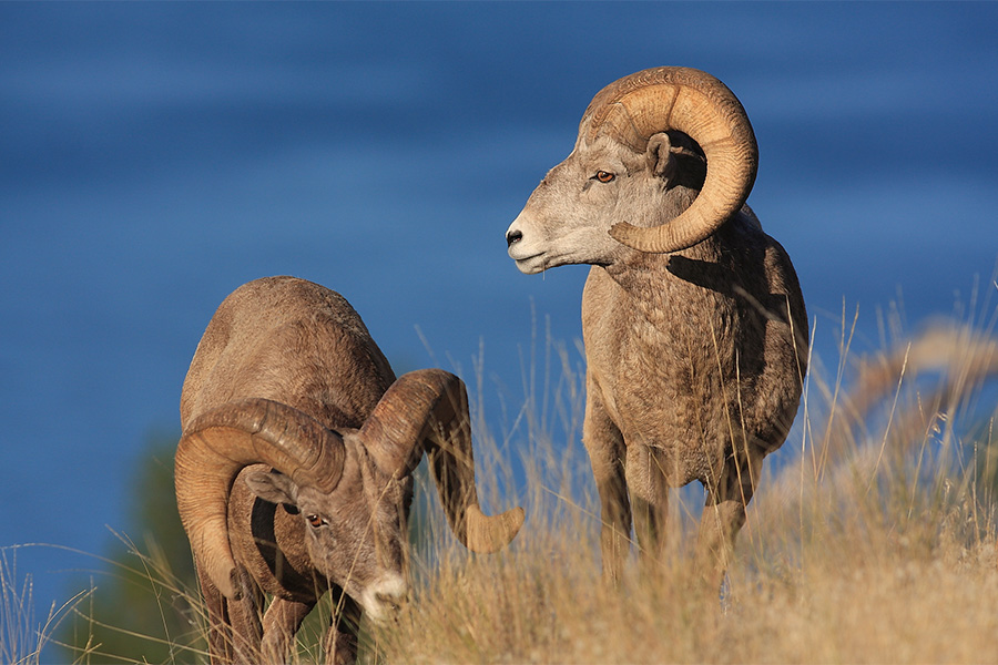
The island is known for wildlife including wild horses and Rocky Mountain bighorn sheep, as well as abundant native grasses and wildflowers.
Other public lands around Flathead Lake include state parks, fishing access sites and the National Wildlife Refuge on the North Shore.
The first wagon trail from Polson to Somers followed the West Shore in the 1880s. The route was steep and hazardous. In some places, travelers had to lower wagons using ropes.
Work on an East Shore road began in 1911, but the road was not completed until 1946. Before its completion, students and researchers traveling to the Flathead Lake Biological Station sometimes arrived by horse or steamboat.
The Flathead Lake Biological Station was established in 1899 by University of Montana biology professor Morton Elrod.
The Biological Station was originally located in Bigfork and later moved to its present location at Yellow Bay.
Maximum Length | 27.3 miles (43.9 km) |
|---|---|
Maximum Width | 15.5 miles (24.9 km) |
Maximum Depth | 370.7 feet (113 m) |
Mean Depth | 164.7 feet (50.2 m) |
Area Covered by Lake | 191.5 sq miles (495.9 sq km) |
Area Covered by Islands | 5.5 sq miles (14.2 sq km) |
Volume of Water | 5.56 cu miles (23.2 cu km) |
Length of Shoreline |
|
Mainland | 161.4 miles (259.7 km) |
Island | 26.2 miles (42.2 km) |
Total | 187.6 miles (301.9 km) |
Curvature of Lake Surface |
|
Length | 13.2 feet (4.02 m) |
Breadth | 5.2 feet (1.58 m) |
Flushing Time | 2.2 years |
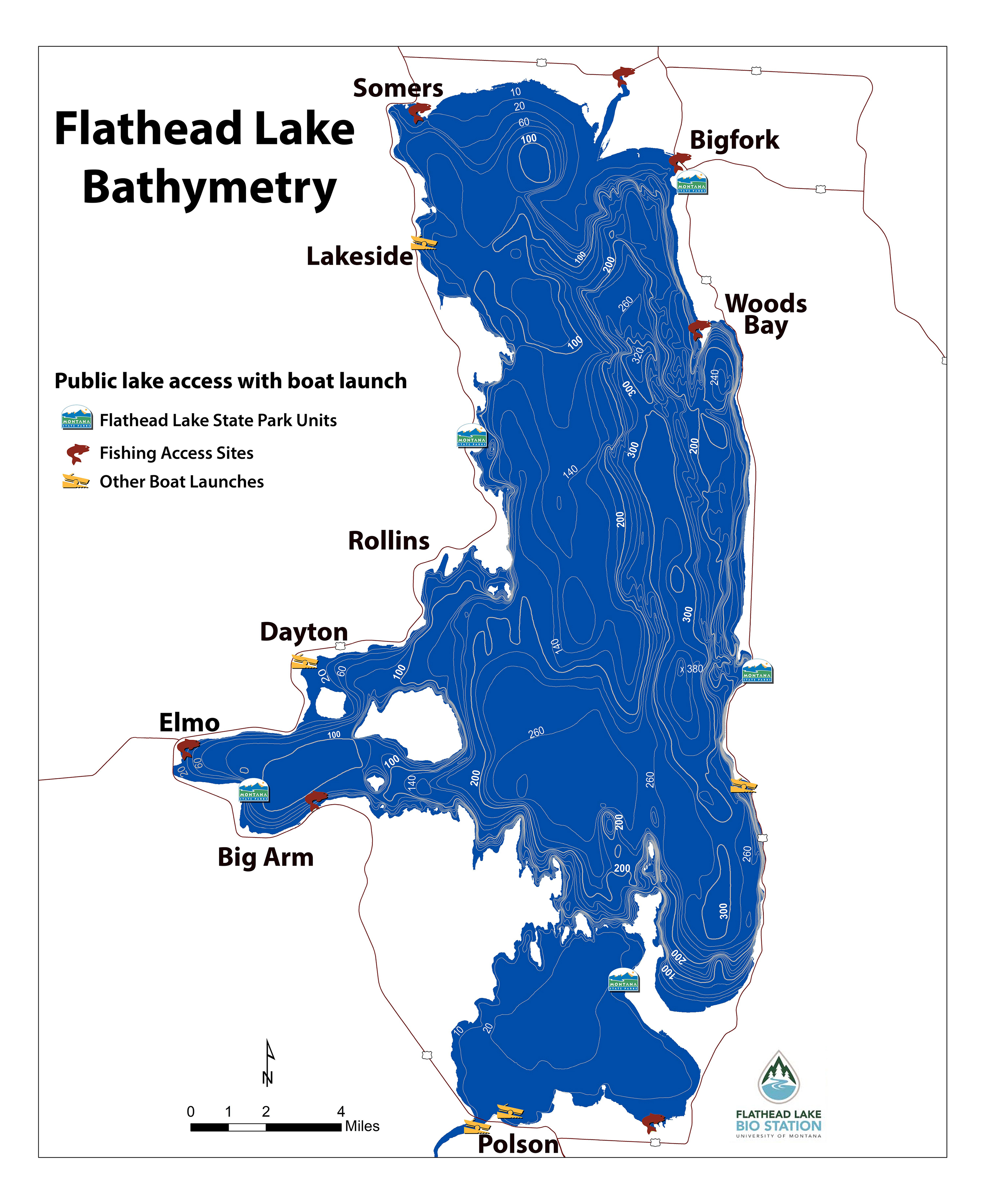
A bathymetric map is like a topographic map of the land beneath the water. It uses contour lines to show the shape and depth of the lake bottom.
The printable FLBS Flathead Lake bathymetric map shows depth contours as well as public access locations around the lake.
The Flathead Lake Biological Station (FLBS) is a University of Montana research and education center located at Yellow Bay on Flathead Lake.
FLBS scientists have studied Flathead Lake and the Flathead watershed for more than a century. Long-term measurements of water quality, weather, aquatic life and other environmental conditions help scientists understand how the lake works and how it changes over time.
This long scientific record helps FLBS provide information to students, researchers, resource managers, decision-makers and communities throughout the region.