Maps, Plates & Store
On This Page:
Flathead Lake 'Keep it Blue' License Plate
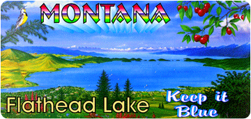
The Flathead Lake Keep It Blue license plate honors our love of and helps us protect Flathead Lake. By requesting the Flathead Lake Keep It Blue license plate at your local MT DMV, you can help FLBS lake monitoring and research.
The Flathead Lake Biological Station monitoring program has described the effects of nutrient increases due to expanding population and changing land use on water quality in the Flathead Basin. These long-term studies provide a basis for minimizing pollution and maintaining the clean, clear water associated with Flathead Lake and the Flathead Lake Keep It Blue plate.
Purchasing the Flathead Lake Keep It Blue plate offers several great benefits:
- Contributes $20 annually to Bio Station water quality monitoring
- Helps protect Flathead Lake
- Shows that you value our waters and quality of life in the Flathead
The Flathead Lake Biological Station relies on your continuing support to maintain monitoring efforts that have kept Flathead Lake one of the most pristine large lakes in the world. The Flathead Lake Keep It Blue license plate helps sustain the sampling necessary to monitor trends in water quality in Flathead Lake and its tributaries.
Flathead Lake is one of the great jewels of the world! Help do your part. Spread the Word. Keep It Blue!
Did you know?
Original artwork for the Keep It Blue license plate was donated by Whitefish artist Glen Prestegaard. Poster reprints of Glen's work may be purchased at Glen's Montana Planet website.
Buy Flathead Lake Plates
How to buy Flathead Lake Keep It Blue license plates
When you register or renew your vehicle registration, ask for the Flathead Lake Keep It Blue license plate.
For more information about the plate, visit the State of Montana website and search for 'Flathead Lake'.
The Flathead Lake Keep It Blue license plate is sponsored by Citizens for a Better Flathead, with proceeds directly supporting Bio Station monitoring efforts.
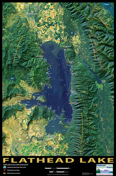
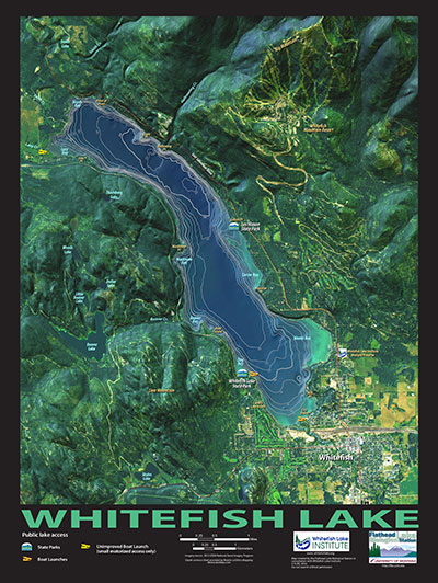
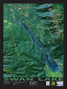
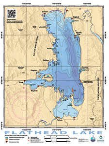
FLBS Flathead / Whitefish / Swan Lake Detail Maps
Over the years, many people have requested a high quality, detailed map of Flathead Lake and its surrounding area. Visitors have even offered to purchase the out-of-print versions that we have hanging on the walls of the Bio Station. We listened and came up with a solution.
FLBS has published several detailed lake maps. These maps are based on satellite imagery of the Flathead watershed and include typical map features with info about lake and terrain features.
All proceeds go toward Flathead/Whitefish/Swan Lake Monitoring and Research.
For more information, email Tom Bansak at FLBS or call 406-872-4503.
Prices
24" x 36" Flathead Lake print : $20.00
18" x 24" Flathead Lake waterproof, Whitefish Lake, Swan Lake : $20.00
Where Can I Buy the FLBS Detail Maps?
Maps are available now at FLBS and at select retail outlets around the Flathead and Mission valleys.
Large Map Features
- Based on 2013 satellite imagery of the Flathead Basin
- Aerial view with labels of major geographic features in the basin, including mountain ranges, lakes, and rivers
- Flathead Lake details include lake depths (bathymetry), point and bay names, and island names
- Flathead Lake public access points include MT State Parks, fishing access sites, and public boat launches
- Photographic quality with a matte black finish
- Makes a beautiful and informative gift to both Flathead visitors and longtime residents
- 24"x36"
Waterproof Version Features
- Same as above, except:
- 18"x24"
- Improved depth detail to assist boaters
- Waterproof!
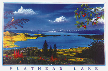
XPlorer Flathead Lake Map
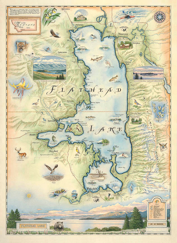
The Flathead Lake Biological Station and the Flathead Lakers have collaborated with Xplorer Maps of Missoula, Montana to create a unique, artistic rendition of Flathead Lake. The result of this effort is a beautiful watercolor antique style print of Flathead Lake and its surroundings with many illustrations of regional flora and fauna.
Xplorer Maps generously donates a portion of the proceeds from this map to FLBS to benefit the long-term understanding and protection of Flathead Lake through our programs.
Xplorer Maps creates hand-drawn and hand-lettered illustrations of significant natural and historical sites throughout the world. The illustrations are geographically accurate and contain interpretive, educational, cultural and historical information. Xplorer Maps has partnered with a variety of organizations, including Glacier National Park and Yellowstone National Park, to raise awareness and funding for conservation of these special natural places.
Xplorer Maps will generously donate a significant portion of the proceeds from this map to the FLBS to benefit the long-term protection of Flathead Lake through FLBS monitoring programs.
Where Can I Buy the XPlorer Flathead Lake Artistic Map?
Poster versions of the Flathead Lake map are now available for purchase at Xplorer Maps. Poster prices begin at $40.