Satellite and Aerial Imagery: Viewing Ecology from Above
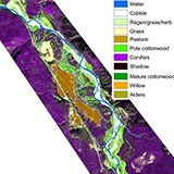
FLBS scientists have extensively utilized, and in fact pioneered, aspects of the use of aerial sensors and imagery (satellite and aircraft mounted) to examine ecological characteristics and patterns. At the watershed scale, FLBS has used multi-spectral imagery from both satellites and aircraft, in concert with on-the-ground Acoustic Doppler Profilers which can measure water depth, velocity and sediment movement, to develop techniques to classify, quantify, and map aquatic and riparian habitat. Additionally, by using Light Detection and Radar (LIDAR), FLBS researchers have constructed detailed topographic maps and information about river flood plains and lake shorelines.
At the global scale, FLBS researchers have worked extensively with NASA’s satellite remote sensing programs (eg Landsat, MODIS and SMAP) and have been involved in the development and oversight of new sensors and analysis techniques. These technologies have resulted in extensive discoveries pertaining to the earth’s soil moisture, drought, freeze thaw cycles, and climate variability.
- Whited, D. C., J. A. Stanford and J. S. Kimball. 2003. Application of airborne multi-spectral digital imagery to characterize the riverine habitat. Verh. Internat. Verein. Limnol. 28(3):1373–1380.
- Lorang, M. S., D. C. Whited, F. R. Hauer, J. S. Kimball and J. A. Stanford. 2005. Using airborne multispectral imagery to evaluate geomorphic work across floodplains of gravel-bed rivers. Ecological Applications 15(4):1209–1222.
- Kimball, J. S. 2008. Earth observation of global change: the role of satellite remote sensing in monitoring the global environment. EOS 89(32):294.
- Zhang, K., J. S. Kimball, Q. Mub, L. A. Jones, S. J. Goetz and S. W. Running. 2009. Satellite based analysis of northern ET trends and associated changes in the regional water balance from 1983 to 2005. Journal of Hydrology 379:92–110.
- Kim, Y., J. S. Kimball, K. Zhang and K. C. McDonald. 2012. Satellite detection of increasing Northern Hemisphere non-frozen seasons from 1979 to 2008: Implications for regional vegetation growth. Remote Sensing of Environment 121:472–487.
- Jones, M. O., J. S. Kimball and L. A. Jones. 2013. Satellite microwave detection of boreal forest recovery from the extreme 2004 wildfires in Alaska and Canada. Global Change Biology 19(10):3111–3122.