Flathead Lake Facts
On this page:
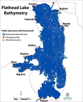
The printable FLBS Flathead Lake bathymetric map shows the depth contours of Flathead Lake, as well as the locations of Flathead Lake public access points.
- The Flathead Lake Biological Station (FLBS) is a year-round University of Montana Center of Excellence that conducts ecological research with an emphasis on fresh water, particularly Flathead Lake and the Flathead watershed. FLBS also provides field ecology courses for college students, natural resource professionals and educators from around the nation; trains graduate students for professional and teaching careers; and provides scientific data, interpretation and outreach to help resolve environmental problems and inform public policy.
- FLBS is one of the oldest active biological stations in the US. It was established in 1899 by Dr. Morton Elrod, the first Biology Professor at the University of Montana. Dr. Elrod was instrumental in the creation of the National Bison Range and Glacier National Park for which he was the first naturalist and wrote its first guide book. FLBS was originally located in Bigfork, but was moved to Yellow Bay in the 1908.
- Flathead Lake is the 79th largest of the natural freshwater lakes in the world, and it is one of the cleanest.
- FLBS serves as the "Sentinel of the Lake", having collected samples and data on Flathead Lake ecology and water quality for over 100 years, providing insights into ecological conditions and changes over time. Indeed, since 1977, FLBS researchers have conducted a rigorous scientific monitoring program. Early sampling showed signs of declining water quality (e.g., increases in algal growth and algal blooms, declines in oxygen in bottom waters) likely due to nutrient pollution from human sources (e.g. untreated or poorly treated sewage) and shoreline erosion. These decreases in water quality led Federal and State agencies to classify Flathead Lake as "Impaired" due to human caused increases in nutrient and sediments, and to work on creating a long-term plan for water quality protection. These changes would have gone unnoticed if FLBS researchers were not conducting rigorous monitoring.
- These observations of early signs of water quality deterioration stimulated one of the nation’s first phosphate detergent bans and the implementation of advanced wastewater treatment plants to head off further water quality deterioration. Recent analyses of our long-term Flathead Monitoring Program data indicate that these efforts were successful – over the past 40 years in-lake concentrations of nitrogen and phosphorus as well as river-borne inputs of nitrogen and phosphorus, while variable within years and year-to-year, show no long-term trends.
- Consistent with this maintenance of low in-lake nutrient levels, Flathead Lake’s renowned water transparency (which in other lakes is often impaired by nutrient-driven algal blooms) has also been maintained at high levels with no long-term trends.
- Average surface temperatures of the Lake range from 2.3°C (36°F) in mid-January to 13.5°C (56°F) in mid-June to 20.3°C (68°F) in mid-August. Maximum surface temperature has recently surpassed 80°F.Flathead Lake is the largest natural freshwater lake in the western US (by surface area) outside of Alaska. Lake Tahoe has more water than Flathead because it is significantly deeper (nearly 1650 ft vs. 380 ft). The Great Salt Lake in Utah is significantly larger than Flathead but is salt, not fresh water. And there are numerous larger man-made reservoirs.
- Average surface temperatures of the Lake range from 2.3°C (36°F) in mid-January to 13.5°C (56°F) in mid-June to 20.3°C (68°F) in mid-August.
- Flathead Lake's biological community is much different today than when FLBS was founded. The Lake originally had 11 native fish species, notably westslope cutthroat trout (Montana State fish) and bull trout (top predator). However, since the late 1800s, fisheries managers have introduced 19 nonnative fishes to "enhance" the Lake and its angling opportunities. These fish introductions, along with the arrival of the nonnative Mysis (opossum) shrimp in the mid-1980s, changed the biological community dramatically. Today, the fish community is more similar to the Great Lakes than Rocky Mountain lakes, as it is dominated by nonnatives, particularly lake trout, lake whitefish and yellow perch.
- Flathead Lake is a remnant of Glacial Lake Missoula, which covered much of Western Montana until roughly 15,000 years ago. Periodic rupturing of the ice dam that created the lake resulted in cataclysmic floods that swept across Washington and Oregon, removing and transporting huge amounts of sediments, creating the scablands of Eastern Washington, and carving out the Columbia River Gorge.
- The Lake's major tributaries are the Flathead and Swan Rivers. There are numerous small streams that flow into the Lake, particularly on the wetter East Shore.
- Maximum river flow in the Flathead generally occurs between May 15 and June 15 during peak snowmelt, creating a sediment plume that can cover the entire lake surface.
- The Lake level and its outflow are regulated by Seli’š Ksanka Qlispe’ Dam, which is located on the Lower Flathead River near Polson. Seli’š Ksanka Qlispe’ Dam was completed in 1938 by the Montana Power Company, raised the Lake level 10 feet above its natural level, and generates 194 megawatts of electricity. It is cooperatively operated by PPL Montana and the Confederated Salish and Kootenai Tribes. Regulation by the dam results in the Lake level fluctuating seasonally 10 feet between 2,883 and 2,893 feet above sea level. If snowpack conditions in the mountains do not threaten flooding, lake level is brought to 2,890 feet by the end of May and to full pool by June 15 for summer recreation.
- Due to its large volume and fetch (distance of water across which wind blows), Flathead Lake requires very cold and calm conditions to freeze entirely. Therefore, most winters it does not freeze over, although some bays and margins have ice cover. FLBS historic observations show that the Lake froze over about once each decade, however the Lake has not entirely frozen since 1988-89 (March only) and 1989-90 (January only), perhaps reflecting warmer climatic conditions.
- Public lands around the Lake include a National Wildlife Refuge on the North Shore, six State Parks (including Yellow Bay which is on FLBS property) managed by Montana Fish Wildlife and Parks (FWP), and nine Fishing Accesses managed by FWP or the Confederated Salish and Kootenai Tribes.
- Wildhorse Island, one of the State Parks, is the largest island in the lake at 2,100 acres, and rises 1,200 feet above the Lake. It is noted for herds of wild horses and Rocky Mountain Bighorn sheep. Native grasses and flowers are abundant.
- The first wagon trail (1880s) from Polson to Somers followed the West Shore of the Lake and was steep and hazardous. In places, wagons were lowered by ropes.
- In 1911, work started from the south end of the Lake to build an East Shore road. The road, which was primarily built by convict labor, was not completed until 1946. Until then, FLBS students and researchers arrived by horse or steamboat.
- Economists estimate that Flathead Lake boosts shoreline property values by $6-$8 billion, nature based tourism (which depends upon a healthy Flathead Lake-River System) accounts for roughly 20% of the $7.8 billion annual economy of Flathead and Lake Counties, and ecological services (e.g., water supply and purification, flood and drought mitigation) contribute another $20+ billion in benefits to human society.
Statistics
| Maximum Length | 27.3 miles (43.9 km) |
|---|---|
| Maximum Width | 15.5 miles (24.9 km) |
| Maximum Depth | 370.7 feet (113 m) |
| Mean Depth | 164.7 feet (50.2 m) |
| Area Covered by Lake | 191.5 sq miles (495.9 sq km) |
| Area Covered by Islands | 5.5 sq miles (14.2 sq km) |
| Volume of Water | 5.56 cu miles (23.2 cu km) |
| Length of Shoreline | |
| Mainland | 161.4 miles (259.7 km) |
| Island | 26.2 miles (42.2 km) |
| Total | 187.6 miles (301.9 km) |
| Curvature of Lake Surface | |
| Length | 13.2 feet (4.02 m) |
| Breadth | 5.2 feet (1.58 m) |
| Flushing Time | 2.2 years |
Fish of the Flathead Basin
| Native | ||
|---|---|---|
| Species, Common Name | Habitats1 | Current Status2,3 |
| Bull trout, Salvelinus confluentus | All | C,D, L |
| Westslope cutthroat trout, Oncorhynchus clarkii lewisi | All | C,D |
| Mountain whitefish, Prosopium williamsoni | All | C,? |
| Pygmy whitefish, Prosopium coulterii | FL,L,A | R,? |
| Largescale sucker, Catostomus macrocheilus | FL,L,R | C,S |
| Longnose sucker, Catostomus catostomus | FL,L,R | C,S |
| Northern pikeminnow, Ptychocheilus oregonensis | FL,L,R | C,S |
| Peamouth chub, Mylocheilus caurinus | FL,L,R | C,S |
| Redside shiner, Richardsonius balteatus | FL,L,R | C,S |
| Slimy sculpin, Cottus cognatus | FL,L,R | C,S |
| Longnose dace, Rhinichthys cataractae | FLR | C,S |
| Nonnative (year introduced) | ||
|---|---|---|
| Species, Common Name | Habitats1 | Current Status2,3 |
| Lake whitefish (1890), Coregonus clupeaformis | All | A,E |
| Lake trout (1905), Salvelinus namaycush | All | A,E |
| Rainbow trout (1914), Oncorhynchus mykiss | FL,L,R | A,E |
| Brook trout (1913), Salvelinus fontinalis | FL,L,R | A,E |
| Yellowstone cutthroat trout (1910s), Oncorhynchus clarkii bouvieri | L,R,A | R4,S |
| Golden trout (1960s), Oncorhynchus mykiss aquabonita | L | R4,S |
| Brown trout (1910s), Salmo trutta | R,FLR | R,? |
| Kokanee salmon (1916), Oncorhynchus nerka | A | R,D |
| Arctic grayling (1960s), Thymallus arcticus | L,R,A | R4,S |
| Yellow perch (1910), Perca flavescens | FL,L | A,S |
| Northern pike (1960s), Esox lucius | FL,L,R | C,E |
| Largemouth bass (1898), Micropterus salmoides | FL,L | R,E |
| Smallmouth bass (1960s), Micropterus dolomieu | FL,L,FLR | C,E |
| Pumpkinseed sunfish (1910), Lepomis gibbosus | FL,L | C,S |
| Black bullhead (1910), Ameiurus melas | FL,L | C,S |
| Central mudminnow (1990s), Umbra limi | L | R,? |
| Brook stickleback (??), Culaea inconstans | FL,L,R | R,? |
| Walleye (??), Sander vitreus | L | R4,? |
| White sucker (??), Catostomus commersonii | L | R4,? |
| Black crappie (??), Pomoxis nigromaculatus | L | R4,? |
1 Habitats: Populations found in: Flathead Lake (FL), other Basin lakes (L), rivers and streams (R), with adfluvial (A) life cycle (adults in lakes, spawn in tributary streams); the Lower Flathead River (FLR) downstream of Seli’š Ksanka Qlispe’ Dam.
2 Distribution: Abundant throughout Basin (A), common in many areas (C) or restricted (R);
3 Trend: Population size stable (S), declining (D), expanding (E), or unknown (?). Listed (L) under the Federal Endangered Species Act.
4 Introduced to a few small lakes in the Basin.
Compiled by FLBS and adapted from: B.K. Ellis, J.A. Stanford et al. 2011; Stanford, J.A. and B.K. Ellis 2002; Holton and Johnson 1996; Montana Fisheries Information System; unpublished records; and professional opinion.2 Distribution: Abundant throughout Basin (A), common in many areas (C) or restricted (R);
3 Trend: Population size stable (S), declining (D), expanding (E), or unknown (?). Listed (L) under the Federal Endangered Species Act.
4 Introduced to a few small lakes in the Basin.
Flathead Lake Bathymetric Map
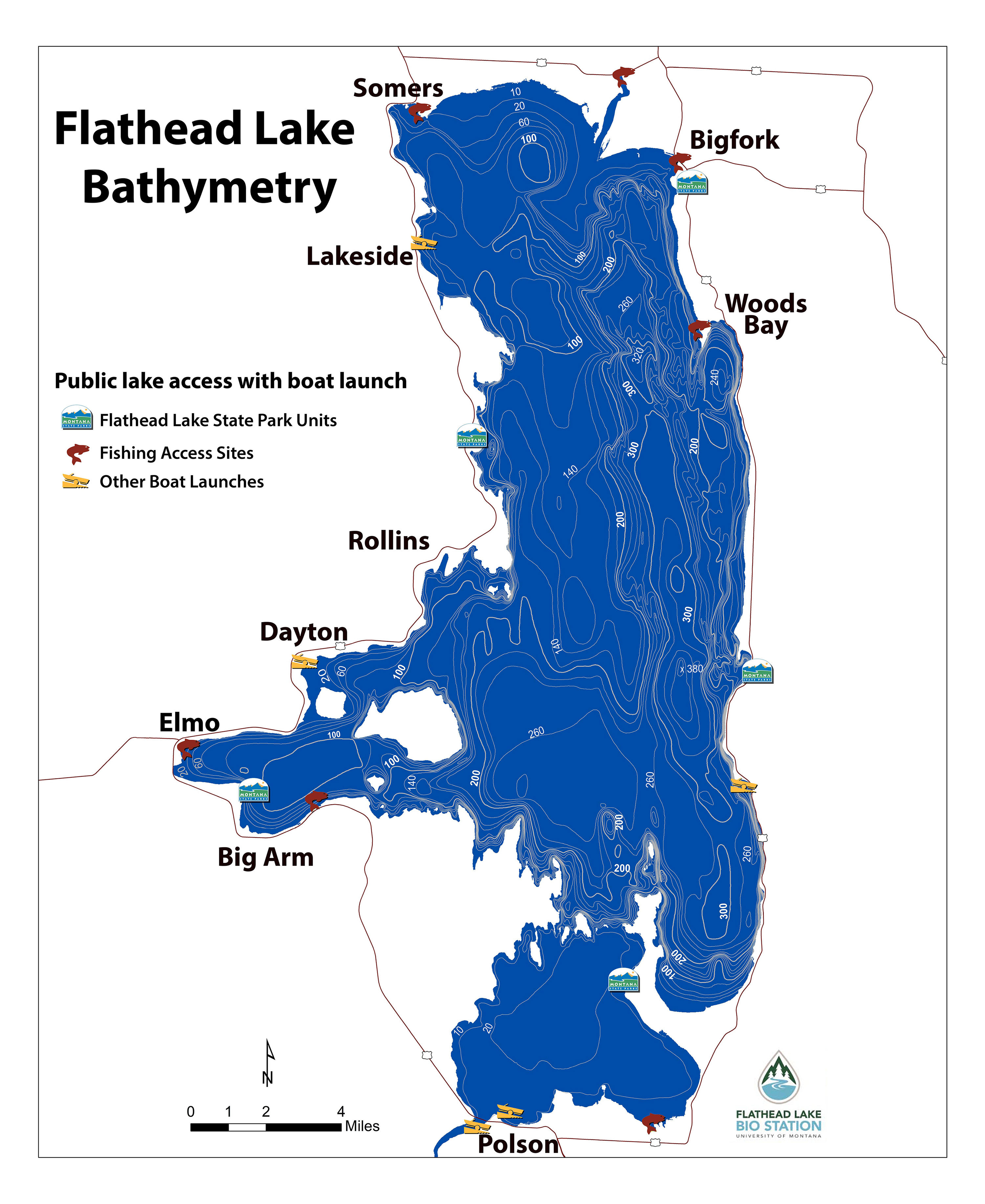
The printable FLBS Flathead Lake bathymetric map shows the depth contours of Flathead Lake, as well as the locations of Flathead Lake public access points.